

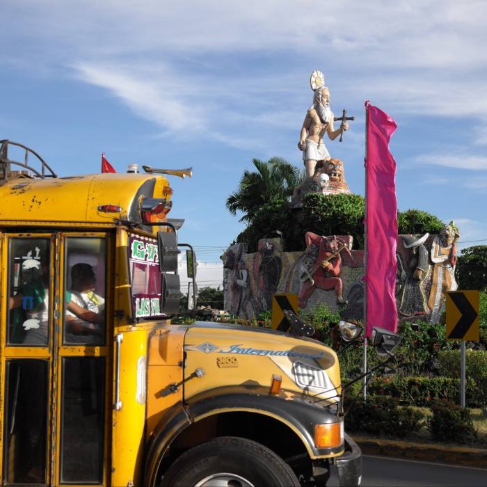
The fireworks began at 9pm on the dot, a stream of stars bursting over the parish church of San Jerónimo. Standing on the steps in front of the church, I had to twist my neck to watch them. It was the only bit of me I could still move. I’d been stuck in a swelling crowd for an hour and more, and it was now impossible to turn around.
Cries from in front interrupted the final starbursts. Down on the street, a swirling mass of humanity opened up, allowing a runner to pass through. He held aloft a small model bull wreathed in shiny, coloured tinsel, which was set alight, bursting into a blaze of deafening firecrackers.
Abruptly, the crowd backed away further on each side of the street, flattening to the curbs like the parting of the Red Sea. Two teams of youths limbered up at either end of the road, perhaps 50 metres apart, dressed in black and wearing face masks — Mexican wrestling masks, superheroes and simple balaclavas. All participants were soaking wet; earlier I’d watched them dousing each other with jugs of water from a large barrel in readiness for Las Bolas de Fuego, the fireball fight.
And then, all hell broke loose. Flaming missiles — rag balls soaked in gasoline — were hurled back and forth between the two groups of youths, and soon the street itself was ablaze with the burning debris. All around me, people were shouting and squealing with delight, smartphones aloft to catch the action, urging the competitors on. What might have come across as a barely contained urban riot was conducted in remarkably good humour, despite the obvious dangers. There were no winners or losers, just a frenzied, adrenaline-fuelled 15 minutes when the town of Nejapa became fireball city.

This fiesta in El Salvador, celebrated each year at the end of August, was a high point in my journey, which started and ended on the flanks of a volcano and followed a volcanic theme throughout. In Nejapa, the festival commemorates the last eruption of the San Salvador volcano in 1917, when great balls of fire rained down harmlessly on the village, so the story goes, because residents clung to an image of San Jerónimo to guarantee their safety.
On a topographical map, Central America is marked by a string of volcanoes extending from Guatemala to Panama. Set in a remarkably neat line 30-70km inland from the Pacific coast, they reflect the meeting of two great slabs of the Earth’s crust: where the Cocos tectonic plate is swallowed up beneath the Caribbean plate. The immense forces involved have left the line of volcanoes punched through the landscape, vents to the underworld that explain many attributes of the culture, history and traditions of the region.
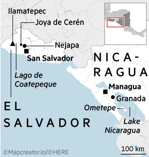
My trip had begun in a rather more sedate atmosphere in next-door Nicaragua on the island of Ometepe: a two-hour drive south-east from the airport at Managua, the capital, followed by 60 minutes on a small ferry. The island is made up of two volcanoes, Maderas and Concepción, rising up out of Lake Nicaragua and connected by a narrow isthmus.
Looped around its twin peaks is Ometepe’s one road. They began paving it in 2006 and are about halfway through the job. They’re in no hurry; just as many people ride horses as motorcycles here. The island has been a magnet for travellers who want to enjoy nature at a hammock-swinging pace, but the island’s airstrip was closed throughout the pandemic and I was the only vacationer on the ferry. Denied their tourist income, residents reverted to farming and fishing.


Inhabited for more than 3,500 years, Ometepe boasts an archaeological heritage of rock art. I saw some examples in the small Museo el Ceibo, a short distance off the road up a track where a white-faced capuchin monkey was perched on a fence post. But once I had my eye in, I spotted the petroglyphs everywhere I went, outside houses, at the foot of telegraph poles, in fields of dragon fruit and sesame. Spirals are the most common motif carved into the basalt boulders, some depicting animals, others human faces — one I saw quite obviously poking its tongue out.
Archaeologists debate their meaning but some of Ometepe’s petroglyphs are associated with human sacrifices to the volcanic gods. When Spanish conquistadors marched into Central America in the 16th century, the Catholic church tried a form of persuasion to end such barbarous practices. Priests chose to convert the malign deities by baptising their volcanoes. They tried it at Masaya, a brooding peak located midway between Lake Nicaragua and Managua, where a giant cross still stands above the Santiago crater, centrepiece of the country’s largest national park.
Masaya is one of a handful of volcanoes globally where you can view an active lava lake. It is also the most accessible one by far, because all you do is pay the park entrance fee and drive up to the car park. A stone wall separates you and the crater. A notice advises people not to hang around for too long, due to the hazardous fumes, and they close the park completely if there’s even a hint of more dramatic activity.


I arrived as the sun was setting. Gaudy green parakeets flashed across the monochrome landscape, flying home in pairs to roost in the cliff walls of the crater. Spanish chroniclers noted the parakeets and they’re still there, one of the few life forms — there are also bats, but no vegetation — that can survive the sulphurous emissions. As the orange-red sunset faded, the red-orange lava began to glow less than 200 metres beneath me. Boiling, spitting and churning, luminescent waves of molten rock crashed below the gently billowing steam.
My day had been spent wandering the cobbled streets of Granada, which claims to be the oldest city in the New World, although most of its colonial mansions and baroque churches are works of restoration. The city suffered multiple waves of destruction thanks to pirate attacks, rebellions and post-independence rivalries, but my hotel, the Real La Merced, had been lovingly rebuilt after a simple case of neglect. The manager proudly showed me sepia photographs, hung around the restored courtyard, of the building’s sorry former state. Constructed in 1910, by the 1980s the entire mansion had disintegrated, leaving just its pink marble staircase, imported from Italy at vast expense, sweeping up to nothing but thin air. My room overlooked the Iglesia de La Merced opposite. On my final morning in Nicaragua, two green parakeets sat high on the church weathervane, as if to bid me farewell.


Elsewhere in this part of the world, many settlements have fallen foul of tectonic forces. In San Salvador, a short flight to the north-west, most of the older buildings destroyed by occasional earthquakes have not been recreated, leaving a largely characterless jumble of concrete. Nejapa, site of the fireball festival, settled at its current location after a volcano near the old village erupted in 1658, forcing residents to flee. However, my first destination in El Salvador was another, much older victim of volcanic action.
Joya de Ceren is a Mayan archaeological site, but without the grandeur of its better-known sisters. It wasn’t a ceremonial centre and there are no pyramids. Dubbed the Pompeii of the Americas, the site uniquely displays a freeze-frame of daily life in an ordinary 7th-century pre-Hispanic farming community. Strolling around the site and its small museum, what struck me most was how little has changed. These people ate maize and beans, still the country’s staple foods. My guide, Dionisio Mejía, explained that the households were constructed of wattle and daub, still widely used in rural El Salvador because it is highly earthquake resistant.
The one difference with Pompeii was the lack of human remains. The Ilopango volcano must have rumbled enough for the villagers to run away before its ash rained down to petrify their village for eternity. The only bodies were a duck in a kitchen and a mouse in the larder.
Mejía was keen to show me some of his country’s other tectonic landscapes. We sped through endless sugarcane fields, where warning triangles alerted drivers to crossing armadillos, and arrived at a lunchtime restaurant with a view. We ate grilled mojarra fish perched high above Lago de Coatepeque, a mesmerising crater lake that changes colour once a year from dark blue to vibrant turquoise. Nobody is sure why. Theories range from a geochemical reaction to sea grass and algal blooms. Whatever the cause — the timing and duration of the change are both unpredictable — it draws people from all over the country. After lunch, we stopped at El Boquerón, or Big Mouth, the San Salvador volcano’s crater that showered hot rocks harmlessly on Nejapa in 1917. That eruption, which destroyed a large part of the nation’s capital — redoubling Nejapa’s joy at being spared — also vaporised the lake that had once sat inside Big Mouth crater.


These craters were both spectacular but, Mejía informed me, the best one required a little more effort. We made it to the top of Ilamatepec, El Salvador’s highest peak at 2,381 metres above sea level, the following morning. The trek was just 3km but for me it was hard work, with frequent stops to admire the views or lack thereof when clouds chose to roll up the slopes. The agave plants grew progressively smaller as we neared the summit, eventually giving up altogether to leave just the bare volcanic rubble. I was rewarded with a steaming lake more vividly turquoise than Coatepeque. In celebration, Mejía produced from his backpack two small bottles of Kolashampan, a bright orange Salvadoran fizzy drink made from sugarcane. It may have just been the sugar rush at altitude, but the stark colour contrast seemed almost psychedelic.

That night was spent at Casa 1800 Cerro Verde, a hotel built high on the southern side of Ilamatepec and with dramatic views over yet another volcano. Izalco only formed in 1770 but began life in spectacular fashion, its frequent explosive eruptions providing a night-time beacon for ships and earning it the nickname Lighthouse of the Pacific.
The high-altitude hotel was built in the 1950s and enjoyed a few good years as the go-to place to view volcanic outbursts. But Izalco’s last eruption was in 1966 and without its central attraction the hotel slowly declined, its fortunes not helped by El Salvador’s civil war. Closed for most of this century, it reopened after refurbishment in October 2021 with a striking modernist design and floor-to-ceiling windows. When I arrived, however, the cloud was so thick visibility was less than 50 metres. The heavens opened at nightfall, the deluge making it hard to sleep.
Next morning, though, peace and quiet had returned and the view from the balcony offered a fitting climax to my journey. Izalco’s perfect cone loomed less than two kilometres away, like my own private volcano, seemingly almost within touching distance.
Nick Middleton is a Fellow in Physical Geography at St Anne’s College, University of Oxford
Details
Nick Middleton was a guest of Journey Latin America (journeylatinamerica.co.uk), which offers a 16-day holiday to Nicaragua and El Salvador visiting the locations mentioned from £4,580 per person, including flights from London, transfers, accommodation and excursions